A virtual exhibit based on selections from Buisseret, David. Mapping the French Empire in North America: An Interpretive Guide to the Exhibition Mounted at the Newberry Library on the Occasion of the 17th Annual Conference of the French Colonial Historical Society (Chicago: The Newberry Library, 1991).
MARITIMES AND THE SAINT LAWRENCE RIVER VALLEY
Even before the expeditions of Jacques Cartier, there had been
fishermen from the French Atlantic and Channel ports working the Grand
Banks off Newfoundland; it was therefore natural that the French
should have entered the New World through the estuary of the Saint
Lawrence River. In this section we attempt to give some idea of what
their settlements looked like, both in the Saint Lawrence valley and
also in the wilds of Labrador. But this region also had substantial
towns, earlier than in the other regions of French settlement, and we
have consequently shown a number of plans of towns and
forts. Eventually, the great bulk of the population, such as it was,
came to be concentrated in the Saint Lawrence valley. But the French
had to man strategic outposts like Louisbourg, because if they lost
control of the approaches to the Saint Lawrence valley, their
settlements in the valley could not long survive.
N. de Beauvilliers, Maps of Labrador, 1715. Cartes Marines, The Newberry Library
These maps come from the collection of over one hundred
manuscript maps known as the "Cartes Marines," which show
the French overseas possessions at the beginning of the eighteenth
century. They seem to have been collected early in the eighteenth
century by some person living at Solothurn, in Switzerland. This
person seems to have had access to some French official material, and
may have been a Huguenot who had taken refuge across the border. The
maps sometimes duplicate, sometimes complete and are sometimes quite
distinct from similar material preserved in the great French national
archives and libraries.The page shown here was the work of N. de
Beauvilliers, an ingénieur du roi active in the first
three decades of the eighteenth century; we know nothing about his
life, except that he worked in Canada and also in the West Indies
(among the cartes marines are his maps of Nevis and
Ile-à-Vache). His style is characteristic of French military
maps of the period, and he was doubtless trained in France. The maps
show two stretches of the coastline along the coast of Labrador facing
onto the St. Lawrence Gulf, from Natashquan to Bradore. The upper map
is a detail of the base established at Bradore in 1703 by Augustin
Legardeur, sieur de Courtemanche. French houses, like those of
"M. de Courtemanche," are shown in groups, with palisades
and fences round their gardens; intermingled among them are the tipis
of the Montaignais employed by Courtemanche as trappers and
fishermen. The settlement thrived on its fishing industry, though
there were frequent disputes with the Inuits to the north.
References: Cole Harris, Gosling, Smith and Trudel.
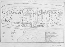
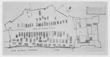
Transcript of an anonymous manuscript plan of Montréal, c. 1710. The Newberry Library; original in Archives Nationales, Paris.
This elegant little drawing is from the Margry Collection of
maps, and shows Montréal about 1710. It is drawn in a rather
naïve style, as a sort of bird's-eye view; we have to take it on
trust that the copyist has faithfully reproduced the original in the
Archives Nationales in Paris.Montréal had been founded in 1642,
but early in the eighteenth century was still a very small town, with
about 150 houses and fewer than 1,500 inhabitants. Using the key, we
can pick out the main buildings. From "A" to "H"
they are all structures related to the church, perhaps a reflection of
the intensely religious nature of Montréal's foundation, as a
center for evangelization among the surrounding Indians."A"
marks the hospital, outside the walls in case of contagion, as was
often the case in Europe at this time. "B" (top left) is the
site of the new monastery of the Recollects, and "H" that of
the Jesuits, at the other end of town, "C" is the large
seminary, and "D" the parish church of Notre Dame, built
between 1672 and 1683. "E" is the huge hospital, largely
staffed by the Soeurs de la Congrégation, whose house
lay just across the green at "F." Close by was the
relatively small prison at "G."Five private houses are also
marked, and we can track down most of their owners. At "I,"
for instance (far right), is the house of "M. Rameses,"
surely Claude de Ramezay, a famous figure in the history of the
settlement whose house was built in 1705 and still stands today. These
are the larger houses among many smaller ones, scattered apparently
without much order within the protecting walls.
References: Cole Harris, Rumilly, and Smith.
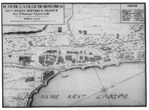
Gaspard Chaussegros de Léry, "Plan de la Ville de
Montréal," 1724. Cartes Marines, The Newberry
Library.
This plan, of which a very similar example survives at the
Archives Nationales in Paris, was the work of Gaspard Chaussegros de
Léry (1682-1756), who worked in Canada from 1716 onwards. It
shows Montréal a little later than "Transcript of an
anonymous manuscript map of Montréal, c. 1710" but in a
very different way. Here the treatment is strictly planimetric, as
opposed to the bird's-eye view, and the interest bears as much on
fortifications as on civilian edifices; Chaussegros de Léry was
a royal engineer, in charge of the defenses. His map shows more area
than the previous one, and succeeds very well in bringing out the
natural features; the hill behind the town, the bluff by the river, a
pool, areas of cultivation and so forth. The town has now been more
effectively fortified, for where a line of palisades ran on
"Transcript of an anonymous manuscript map of
Montréal" (on the river side) there is now a regular
bastioned trace, with a series of "portes" or gates. Various
cultivated areas are shown by the town, but it is difficult to see if
they represent vegetable-gardens or orchards, or both. Within the
walls, the streets now give the impression of being set in a more
orderly fashion, and virtually every house seems to have a garden
attached to it. The new military installations are particularly
conspicuous. At "C" is a powder magazine, no doubt of the
usual type with a steeply-pitched roof to deflect plunging fire. At
"A" there is a parade-ground, flanked by a royal storehouse
("T") and a guard-house ("V"). The city remains
small, but it is beginning to become a fortified center of some
strength.
References: Cole Harris, Trudel 1968 and Vachon 1985
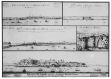
Anonymous manuscript views of Québec, Montréal and
Trois Rivières, c. 1715. Cartes Marines, The Newberry
Library.
This densely packed page contains views of the three leading
towns of New France, a view of Fort de Chambly and also one of Niagara
Falls. On the view of Montréal we can identify the buildings
shown on "Transcript of an anonymous manuscript map of
Montréal" and Chaussegros de Léry's "Plan de
la Ville de Montréal," joined now by an external fort
("Redoute de coteau," top right). The lowest image shows
Québec as seen from the Saint Lawrence, with the merchants'
houses in the foreground on the plain by the river, and the royal and
ecclesiastical establishments behind them on the hill. Prominent also
is the windmill, placed to catch the breeze off the river. The view of
Trois Rivières introduces us to the third urban center in early
eighteenth-century New France. It had been founded in 1634 as a
trading-post, and was much smaller than Québec or
Montréal, but it did have a king's house, a powder magazine, a
prison, a church served by the Recollects and a hospital run by the
Ursulines, who also looked after a girls' school; in time it would
become the major center between Québec and
Montréal. Fort de Chambly, named after Captain Jacques de
Chambly, captain in the Carignan-Salières regiment, lay by the
rapids on the Richelieu River, about fifteen miles south of
Montréal. It was fortified by Chaussegros de Léry in
1712, taking the form shown on our image. If we could see it in plan,
we would see that it was basically a square, with a bastion at each of
the four corners. Chambly never became an important center, and the
fort was allowed to fall into ruins. Since 1921, in has been Fort
Chambly National Historic Park, and the fort has been restored.
References: Charbonneau, Cole Harris and Vachon 1985
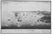
Anonymous manuscript view of Louisbourg, c. 1716. Cartes Marines,
The Newberry Library.
In the early eighteenth century,
the French government decided to establish a base on Cape Breton
Island, from which French forces could both control the mouth of the
Saint Lawrence River, and also offer protection to French fishermen on
the Newfoundland Banks. Our manuscript view, which seems to be unique,
shows the site chosen for this base, which became known as
Louisbourg. The view is of interest not only for the military
installations that it shows, but also for its evidence of cod-fishing.
On the horizon, above the left-hand peninsula, are two "Ds,"
which mark the "place where the fortifications must run"
(they were begun in 1719). Below the right-hand "D" is an
"A," marking the "church surrounded by the principal
houses," in which no doubt the fishermen had lived until
then. Sticking out into the bay, here and at other places, are the
installations marked "F," which are the piers at which the
fish were landed. After being gutted, they were hung up to dry on the
racks marked "L." On each side of the harbor-entrance, and
"E," are the batteries of cannons which defended it, but
which would soon be supplanted by a great fortress on the left-hand
headland. Around the fortress, which seemed impregnable in the 1720s
and 1730s, the fishing colony continued to thrive, and was joined by a
small but prosperous merchant community. Alas, Louisbourg looked
stronger than it was. When war broke out with the English, it was
captured in 1745; restored in 1748, it was again captured in 1758, and
then razed by the English, who concentrated on developing their own
base at Halifax. In our own times, Louisbourg has been extensively
restored, and is not a very striking example of a great European
overseas base at the beginning of the period of general imperial
expansion.
Cole Harris, Fry, Trudel and Vachon 1985
Louis-Joseph Franquet, Manuscript plan of the fort at
Sault-Saint-Louis (near Montréal), 1752. The Newberry
Library.
Louis-Joseph Franquet (1697-1768) was a member of a dynasty of
engineers originating near Lille, in northern France. He came to
Canada in 1750, worked a good deal at Louisbourg, and in 1758 was
captured by the English, after which he retired. He was a prolific
author, writing about the economic potential of the French colonies,
and about the manners and customs of the Indians whom he encountered
at various French settlements. This plan was drawn soon after his
arrival, in 1752, and a similar copy exists at the Bibliothèque
de l'Inspection du Génie in Paris. It shows the work to be done
at the fort and Indian village at Sault-Saint-Louis (Caughnawaga) near
Montréal. Inside the fort is the only building marked on the
key; it is at "C," upper left, the "house of the French
merchants called Desauniers." The fort also has a guard-house
(upper right), and a chapel and house for the Jesuits (bottom); there
are also several gardens. The "village des sauvages
Iroquois" lies outside the fort, but within its own palisaded
enclosure. There are about 75 large longhouses, and a number of
smaller ones; it is hard to assess the number of Iroquois who might
have lived here. This distinctive mission was by the middle of the
eighteenth century only one among others established in different
tribal areas. They included Lorette (Hurons), Saint-François
and Bécancour (Abenakis) and Lac des Deux-Montagnes (Algonkins,
Nipissings, and Iroquois).
References: Blanchard 1981, Cole Harris, Smith and Vachon 1985
 These maps come from the collection of over one hundred
manuscript maps known as the "Cartes Marines," which show
the French overseas possessions at the beginning of the eighteenth
century. They seem to have been collected early in the eighteenth
century by some person living at Solothurn, in Switzerland. This
person seems to have had access to some French official material, and
may have been a Huguenot who had taken refuge across the border. The
maps sometimes duplicate, sometimes complete and are sometimes quite
distinct from similar material preserved in the great French national
archives and libraries.The page shown here was the work of N. de
Beauvilliers, an ingénieur du roi active in the first
three decades of the eighteenth century; we know nothing about his
life, except that he worked in Canada and also in the West Indies
(among the cartes marines are his maps of Nevis and
Ile-à-Vache). His style is characteristic of French military
maps of the period, and he was doubtless trained in France. The maps
show two stretches of the coastline along the coast of Labrador facing
onto the St. Lawrence Gulf, from Natashquan to Bradore. The upper map
is a detail of the base established at Bradore in 1703 by Augustin
Legardeur, sieur de Courtemanche. French houses, like those of
"M. de Courtemanche," are shown in groups, with palisades
and fences round their gardens; intermingled among them are the tipis
of the Montaignais employed by Courtemanche as trappers and
fishermen. The settlement thrived on its fishing industry, though
there were frequent disputes with the Inuits to the north.
These maps come from the collection of over one hundred
manuscript maps known as the "Cartes Marines," which show
the French overseas possessions at the beginning of the eighteenth
century. They seem to have been collected early in the eighteenth
century by some person living at Solothurn, in Switzerland. This
person seems to have had access to some French official material, and
may have been a Huguenot who had taken refuge across the border. The
maps sometimes duplicate, sometimes complete and are sometimes quite
distinct from similar material preserved in the great French national
archives and libraries.The page shown here was the work of N. de
Beauvilliers, an ingénieur du roi active in the first
three decades of the eighteenth century; we know nothing about his
life, except that he worked in Canada and also in the West Indies
(among the cartes marines are his maps of Nevis and
Ile-à-Vache). His style is characteristic of French military
maps of the period, and he was doubtless trained in France. The maps
show two stretches of the coastline along the coast of Labrador facing
onto the St. Lawrence Gulf, from Natashquan to Bradore. The upper map
is a detail of the base established at Bradore in 1703 by Augustin
Legardeur, sieur de Courtemanche. French houses, like those of
"M. de Courtemanche," are shown in groups, with palisades
and fences round their gardens; intermingled among them are the tipis
of the Montaignais employed by Courtemanche as trappers and
fishermen. The settlement thrived on its fishing industry, though
there were frequent disputes with the Inuits to the north.