Thomas Jefferson's Notes on Virginia
The Louisiana Purchase
| | |
The Louisiana Purchase
In April 1803, American diplomats in Paris agreed to purchase from France “Louisiana,” the unsurveyed and largely unknown inland territory between the Mississippi River and the Rocky Mountains. Napoleon had acquired this territory from Spain two years earlier with the hope of creating a new French empire in North America, but a slave revolt in Haiti and the prospect of a war with England had dimmed that dream.
Anxious to acquire New Orleans, the Americans originally had offered $2 million to buy the port city and nearby “West Florida” (the coast of modern Mississippi and Alabama), but the French emperor offered to turn over all his North American territories for $15 million. The Americans lacked instructions for responding to this proposal, but they agreed anyway. They could not pass up an offer of 800,000 square miles of new territory. Congress ratified the sale in October 1803, just as Captains Lewis and Clark were assembling their Corps of Discovery in St. Louis.
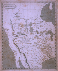
When Philadelphia cartographer Samuel Lewis drew this map of America’s new territory in the West, he put into print a series of common assumptions about the western portion of Louisiana Territory. Lewis assumed the Missouri River drainage extended nearly to the Pacific and that gaps in the mountain ranges would enable travelers to pass relatively easily to the coast. Lewis and Clark shared many of Samuel Lewis’s erroneous hopes.
|
| Click to Enlarge | Roger Baskes Collection, Chicago Illinois |
Samuel Lewis. “Louisiana,” in A New and Elegant
General Atlas of North America, Comprising All the New Discoveries, to the
Present Time; Containing Sixty Five Maps, Drawn by Arrowsmith and Lewis,
1804.
|