Early Map of the Expedition
William Clark and Prince Maximilian
What Happened to the Corps?
Catlin's Depiction
| | |
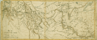
Early Map of the Expedition
In December 1810, William Clark drew a three foot by five foot map of his route to the Pacific for Nicholas Biddle, the Philadelphia editor then preparing the official history of the expedition. Clark also recommended that the editor solicit the help of George Shannon, a private in the Corps of Discovery. In 1811, Biddle wrote to Clark to report that he and Shannon had modified Clark’s map “to make it illustrate the route principally.” When Biddle’s History appeared in 1814, it contained a long, narrow engraved map.
This manuscript map is believed to have been drawn by Shannon as a guide to the engraver. It was unknown to scholars until very recently, when it was acquired by a Chicago collector who has kindly allowed the Newberry to include it in this exhibition.
A Map of Lewis and Clark’s Track Across the Western
Portion of North America from the Mississippi to the Pacific Ocean. Ink and pencil on paper, 1811.
|
| Click to Enlarge | Private Collection |
|