| |
|
Mapping Movement: Spatial Narratives in Popular Cartography
|
|
|
Collected here are maps that demonstrate how cartography records dynamic movement through space. These four seemingly disparate maps display varied ways American cartographers, governments, and corporate entities envisioned human progress through space. Far from being static representations of landscape, all four maps encourage viewer participation in telling the individual stories of movement.
|
| |
|
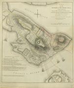
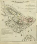
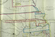
  A map of the Battle of Bunker Hill and a map of the Nebraska and Kansas Territories in 1854 demonstrate varied methods of illustrating movement by showing the “before” and “after” of historic events. Using a fold-over inset, the viewer engages in the construction of this Revolutionary War battle narrative by imagining troop and artillery movement between the two moments plotted on the map and on the inset. A map of the Battle of Bunker Hill and a map of the Nebraska and Kansas Territories in 1854 demonstrate varied methods of illustrating movement by showing the “before” and “after” of historic events. Using a fold-over inset, the viewer engages in the construction of this Revolutionary War battle narrative by imagining troop and artillery movement between the two moments plotted on the map and on the inset.  Likewise,the makers of the Nebraska and Kansas map represent movement—the removal of Indian populations into reservations—through a standard topographical map enhanced by “before” and “after” colored boundaries inscribed in the landscape. The lack of directional line graphics requires the viewer to imagine the narrative of forced movement to smaller lands. Likewise,the makers of the Nebraska and Kansas map represent movement—the removal of Indian populations into reservations—through a standard topographical map enhanced by “before” and “after” colored boundaries inscribed in the landscape. The lack of directional line graphics requires the viewer to imagine the narrative of forced movement to smaller lands.
|
| |
|
 Transportation maps direct the viewer’s participation by charting the route overtly onthe landscape. This 1875 map shows a train route through theWestern-American landscape. A single black line highlights the route, promoting a simplified image of the potential journey rather than conveying details about the terrain. To further encourage travel, the small amount of geographic detail that does appear behind the routeline blends into scenic engravings below the route, engaging the viewer in an imaginary journey. Transportation maps direct the viewer’s participation by charting the route overtly onthe landscape. This 1875 map shows a train route through theWestern-American landscape. A single black line highlights the route, promoting a simplified image of the potential journey rather than conveying details about the terrain. To further encourage travel, the small amount of geographic detail that does appear behind the routeline blends into scenic engravings below the route, engaging the viewer in an imaginary journey.
|
| |
|
 Covering a route from Chicago to California, this 1932 United Air Lines Map and Air Log shares the conventions of the railroad map, including place names, geographic features, timetables, and attractions, and inscribes a clear sense of itinerary and direction through a red line representing a concrete and tangible route across the landscape. That this is an air route projected onto the ground suggests the industry hoped to make air travel more familiar to the wary novice. Covering a route from Chicago to California, this 1932 United Air Lines Map and Air Log shares the conventions of the railroad map, including place names, geographic features, timetables, and attractions, and inscribes a clear sense of itinerary and direction through a red line representing a concrete and tangible route across the landscape. That this is an air route projected onto the ground suggests the industry hoped to make air travel more familiar to the wary novice.
|
| |
|
Although they usevaried methods of illustrating movement, these maps require imagination to unfold their implicit narratives, further enhancing the meaning ofthe maps themselves.
|
| |
|
- Deirdre Egan (St. Norbert College)
-Darin Jensen (University of California, Berkeley)
-Laura Milsk Fowler (Southern Illinois University Edwardsville)
-Nichole Wiedemann (The University of Texas at Austin)
|


