 |
| The Geography of American Communities
Map 16 - A Farm in Menard County, Illinois, 1874 |
|
|
|
|
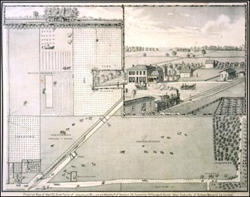
Core Map: "Pictorial Map of the 130 Acre Farm of Jonathan Miller, on West half of section 36, Township 18, Range 6, Northwest suburbs of Athens, Menard Co., Illinois." In Illustrated Atlas of Menard County, Illinois (Edwardsville, IL: W. R. Brink & Co., 1874). Newberry Library call number: +F896565.43.
|
|
This map of Jonathan Miller's farm offers an excellent introduction to the
relationship between geography and American communities. The supplemental
maps and texts from the county atlas demonstrate the ways in which
Americans have divided land in an effort to create communities as well as
the way in which communities transcend political and geographical boundaries.
Lesson Plans
K-2 - Down on the Farm
3-5 - Country Mouse, City Mouse?
6-8 - Prairie Settlement
9-12 - Expanding Communities
|
| | © 2002, 2003 The Newberry Library |
| |
|
