The Historical Geography of Transportation
Map 12 - Auto Trails of Florida, ca. 1924
Florida Auto Trails Map
Core Map
: Rand McNally Junior Auto Trails Map, Florida (Chicago: Rand McNally for Texaco, ca. 1924). Newberry Library call number: RMcN AE 017.2   © 1924 by RMC, R.L.03-S-87. www.randmcnally.com

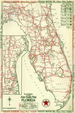
Based on Rand McNally & Co.'s Junior Auto Trails Map of Florida, ca. 1924, these lessons help students understand the history of commercial travel and tourism. The activities discuss measuring distance, the impact of transportation systems on individuals and communities, and the physical and technological changes that have taken place in our national ground transportation system.

Lesson Plans

  • K-2 - How Far Away
  • 3-5 - Naming Roads
  • 6-8 - Keeping a Travel Diary
  • 9-12 - Fulfilling the Visions

    Resources (including supplemental images)

  • © 2002, 2003   The Newberry Library
    top of page    
    Home Map and Lesson Index For Teachers About this Site Glossary of Key Terms