|
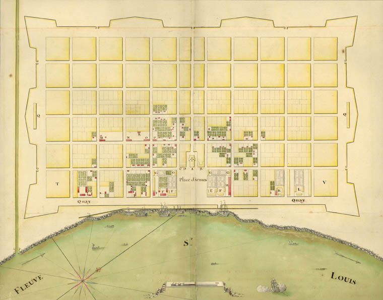
Anon: Plan de la ville de la Nouvelle Orleans (Plan of the City of New Orleans) 1723. Newberry Library call number: Ayer ms map 30, no. 81.
English Translation - Plan of the City of New Orleans on which are marked the addition of houses built between September 3 and the last day of December of the year 1722. That which exists is marked in red, and that which is in yellow is projected.
Key to Locations on the Map
The original French spelling is given first, followed by its English translation. Please note that the French spellings may not be the way they are spelled in modern French today and that one French league equals approximately three miles.
- Eglise / church
- Presbitaire / presbytery (rectory, the priests' residence)
- Corps de garde / guardhouse
- Prison / prison
- Maison de Commandant gen'al / residence of the military commander
- Maisons des Directeurs / residences of the directors of the colony
- Logements des officiers et major de la Place / officers' quarters and the town commander (mayor)
- Grand magazin qui n'est pas tout ŕ fait achevé / the great magazine (ammunition storage facility) that has not yet been built
- Magazin / magazine
- Hopital / hospital
- Arcenal / arsenal
- Cazerne des Ouvriers Suisses / Swiss laborers' barracks
- Cazerne des Ouvriers Allemands / German laborers' barracks
- Cazerne des Ouvriers Francois / French laborers' barracks
- Caserne des Ouvriers Menuifiers / carpenters' barracks
- Casernes de Soldats / soldiers' barracks
- Forge / forge
- Maison qui sert d'Eglise / House which is serving as a church
|