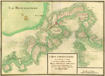
Migration and Settlement Map 4 - "Nouvelle Orleans" and Nearby French Settlements, ca. 1723
Core Map: Anon., "Carte Particuliere du flevue [flueve] St. Louis dix lieües au dessus et au dessous de la Nouvelle Orleans" (A particular map of the St. Louis River [Mississippi River] ten leagues above and below New Orleans, on which are marked the homes and lands granted to some private individuals along the Mississippi) (ca. 1723), in Cartes Marines. Newberry Library call number: Ayer ms map 30, no. 80
These lessons are based on a manuscript map of the course of the Mississippi River in the vicinity of New Orleans in the early eighteenth century, when Louisiana was a French colony. The map is an ideal platform for learning about the settlement and adaptation of colonial communities to unfamiliar environments.