| Popular Cartography Exhibits |

Westward the Course of Empire Takes Its Way
Seldom neutral instruments, maps often support the exploration and development of desired territories. Mapmakers both illustrate the strategic importance of a region and communicate the viability of developing the area. Maps become instruments of persuasion. By discouraging inaction and alternative projects, they work to convince those in power of the viability of proposed projects.
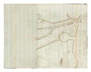 This 1694 annotated manuscript map was sent by its maker, an Anglican missionary, to Maryland’s governor. It conveys information about the lower Mississippi and lands west of the river. Inscriptions concern natural resources, natives, Spanish settlements, dangers, and distances. The map urges English expansion at a critical time, when the power struggles of France and Spain were making westward exploration and new Indian alliances possible. Immured in the northeast, the English had focused on transatlantic trade. La Salle’s failure to colonize the river's mouth encouraged them to explore the American southwest, and to secure strategic control of the lower Mississippi.
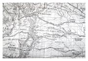
![]() By 1854, the United Sates had secured the Louisiana territory and the young country looked to further expand its economic horizons. The text accompanying these maps asserted that the transcontinental railroad would knit together the “possessions now rising rapidly into importance in that portion of the Continent.” It would also connect prominent commercial centers in the east with new ports on the Pacific coast, facilitating lucrative trade relationships with populous Asian countries. Here, maps described the potential of westward expansion, while landscape images envisioned this growth.
By 1854, the United Sates had secured the Louisiana territory and the young country looked to further expand its economic horizons. The text accompanying these maps asserted that the transcontinental railroad would knit together the “possessions now rising rapidly into importance in that portion of the Continent.” It would also connect prominent commercial centers in the east with new ports on the Pacific coast, facilitating lucrative trade relationships with populous Asian countries. Here, maps described the potential of westward expansion, while landscape images envisioned this growth.
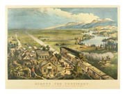 The power of railroads to bring economic expansion is emphatically expressed in this 1868 Currier and Ives print. In the foreground, a train sweeps into a new town bustling with activity. Beyond the town, dominating the view, appears a broad, open plain framed by mountains. This image, like the maps, evokes a vast emptiness, awaiting anticipated economic and social progress.
- Magali Carrera (University of Massachusetts–Dartmouth)
- Janet Halpin (Chicago State University)
- Jonathan Lewis (Benedictine University)
- Judy Schaaf (University of Massachusetts–Dartmouth)