| |
Colonial Mapping: Hawai’i and Africa |
| |
Colonial projects relied heavily on cartographic technologies. These maps were both produced as part of the colonial education apparatus, but differences become apparent in large part through the role of their producers in this apparatus. |
| |
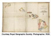 This map of Hawai’i was produced in 1838 by Lorrin Andrews and his mission students at the Lahainaluna Seminary on Maui. In the service of teaching Hawaiian students reading, writing, and geography, Andrews became a self-taught printer and engraver who produced Hawaiian language books, maps, and the first newspaper. This map is notable for being the first to record indigenous Hawaiian land divisions, the ahupua’a and districts for all the islands of Hawai’i based on information provided by the seminary students. These indigenous divisions were used as the basis of the land distribution decisions made in the 1840s in accordance with the Great Mahele - the act that allowed for further division of and privatization of communal land. This map of Hawai’i was produced in 1838 by Lorrin Andrews and his mission students at the Lahainaluna Seminary on Maui. In the service of teaching Hawaiian students reading, writing, and geography, Andrews became a self-taught printer and engraver who produced Hawaiian language books, maps, and the first newspaper. This map is notable for being the first to record indigenous Hawaiian land divisions, the ahupua’a and districts for all the islands of Hawai’i based on information provided by the seminary students. These indigenous divisions were used as the basis of the land distribution decisions made in the 1840s in accordance with the Great Mahele - the act that allowed for further division of and privatization of communal land.
|
| |
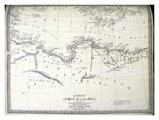 This map of West Africa was produced by the Society for the Diffusion of Useful Knowledge, whose mission was to make educational materials widely affordable and available. Nevertheless, this map featured Europeans producing knowledge for a European audience. The map labels the coastal regions of most significance to Europeans—the Grain Coast, Ivory Coast and the Gold Coast—as well as ethnic groups of which Europeans were most aware: Folahs, Mandingo, Ashanti, Borgou, Haussa, and Igbo. The map highlights the role of European exploration in West Africa. It details stops for European explorers traveling throughout the western and central portion detail. This map of West Africa was produced by the Society for the Diffusion of Useful Knowledge, whose mission was to make educational materials widely affordable and available. Nevertheless, this map featured Europeans producing knowledge for a European audience. The map labels the coastal regions of most significance to Europeans—the Grain Coast, Ivory Coast and the Gold Coast—as well as ethnic groups of which Europeans were most aware: Folahs, Mandingo, Ashanti, Borgou, Haussa, and Igbo. The map highlights the role of European exploration in West Africa. It details stops for European explorers traveling throughout the western and central portion detail.
|
| |
Though both maps relied in part on the technologies of European science, the Hawai’i map shows indigenous land divisions, while the West Africa map highlights the knowledge gained by European explorers. As a result, a scientific sterility marks the African map in a way that does not characterize the Hawaiian map. Though produced by a group prioritizing scientific objectivity over colonial domination, the Africa map highlights information useful to European colonists. In contrast, the Hawaiian map (though also potentially useful to colonialists) brings out aspects of Hawaiian society previously of little interest to European cartographers. |
| |
References: Fitzpatrick, Gary. The Early Mapping of Hawai’i. Honolulu: Editions Limited. Honolulu, Hawaii: Editions Limited, 1986. Healy, John Raymond. “The Mapping of the Hawaiian Islands from 1778 to 1848,” Master’s thesis, University of Hawai’i, 1959. Smith, Harold. The Society for the Diffusion of Useful Knowledge, 1826-1846: A Social and Bibliographical Evaluation. Halifax, N.S.: Dalhousie University, University Libraries, School of Library Service, 1974. Society for the Diffusion of Useful Knowledge. Maps of the Society for the Diffusion of Useful Knowledge. London: Chapman and Hall, 1844. |
| |
- JoAnne Brigham (Houston Community College)
-Lisa Kahaleole Hall (Oberlin College)
-Curtis Keyes, Jr. (East-West University)
-Ethan Yorgason (Brigham Young University, Hawai’i) |
