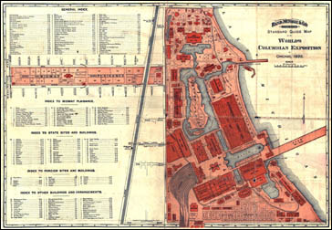
The Geography of American Communities Map 17 - The The Global Community Meets at Chicago's World's Columbian Exposition, 1893
Core Map:Indexed Standard Guide Map of the World's Columbian Exposition at Chicago (Chicago: Rand McNally, 1893). Newberry Library call number: Map 2F oG104.C6:2W6
These lessons are based on a guide map to the Chicago World's Fair of 1893, one of the most ambitious fairs ever staged and a landmark in the history of the development of urban public spaces and amusements in the United States. The map yields a variety of information about the ways in which Americans entertained themselves and moved about on the eve of the automobile age. Like the fair it mapped, it's also a remarkably compact document of the values and hopes for the future Americans treasured during the gilded age.