Theme: Environmental History Map 9 - Tourism, Water, Power, and Conservation in Yosemite National Park, ca. 1935
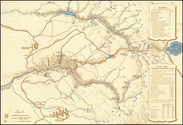
Core Map: [Tourist Map of the Yosemite District, 1936] in Plumb, Stanley, ed. The Four Seasons in Yosemite National Park. Yosemite Park and Curry Co., 1936. Newberry Library call number: Case folio F868 .Y6A33 1940
Our core map, showing the major features of Yosemite National Park, was published in 1936 by the Yosemite Park and Curry Co. as part of a souvenir booklet for visitors to the park. The park has been the focus of important public debates about appropriate human uses of the environment for more than a century, and is an excellent platform for student exploration of these important issues.
Lesson Plans
K-2 - Natural or Cultural?: The Features of Yosemite Park