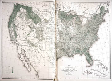
Environmental History Map 7 - The Distribution of Woodland in the United States, 1873
Core Map: William H. Brewer, "Map Showing in Five Degrees of Density the Distribution of Woodland within the Territory of the United States," (Washington, 1873). In Francis A. Walker, Statistical Atlas of the United States Based on the Results of the Ninth Census, 1870 (Washington, 1874). Newberry Library call number: Govt I 10.2 At 6(1)
The core map in this module is a thematic map of the United States showing the distribution of wooded land in 1870. The map is an ideal platform for learning about the usefulness of forests as a natural resource, deforestation, and the human impacts of environmental change.