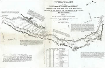
Migration and Settlement Map 5 - Frémont Surveys the Road from Missouri to Oregon, 1843
Core Map: Charles Preuss, "Section VI" of Topographical map of the road from Missouri to Oregon...From the field notes and journal of Capt. J.C. Frémont and from sketches and notes made on the ground by his assistant Charles Preuss (Baltimore 1846). Newberry Library call number: Graff 3360, sheet 6.
The core map was drawn by the German-American cartographer Charles Preuss under the leadership of Captain J.C. Frémont. It took two trips for Frémont's company to travel the route from Westport Landing on the Missouri River to Fort Walla Walla on the Columbia River. The resulting map shows the major route and the landscape on either side and it is richly annotated with information useful to travelers from Preuss' and Frémont's notes. The map and its annotations are a rich introduction to and source for the study of the American settlements in the lands west of the Mississippi River.