 |
| Exploration and Encounter
Map 3 - Captain Cook and Hawaii, 1778
|
|
|
|
|
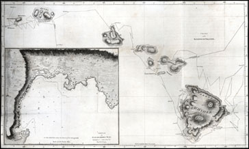
Core Map: William Bligh, "Chart of the Sandwich Islands," from James Cook and James King, A Voyage to the Pacific Ocean…in the Years 1776, 1777, 1778, 1779, and 1780, 2nd. Ed. 3 vols. London: G. Nicol and T. Cadell, 1785. Newberry call Number: Case fG 13.19 Vol. 3 opp. 2.
|
|
Bligh's chart of the Sandwich Islands (Hawaii), the journal of James Cook and James King, and drawings from an atlas that accompany the journal provide first hand accounts of European exploration and early encounters between Europeans and the people of Hawaii. The lesson plans outline activities designed to stimulate students' appreciation and understanding of early encounters between people of different cultures, of eighteenth-century maritime travel, and of the geography of Hawaii.
Lesson Plans
K-2 - A First Encounter
3-5 - Of Compasses, Sextants and Chronometers
6-8 - Island Encounters
9-12 - Captain Cook and the Enlightenment
|
| | © 2002, 2003 The Newberry Library |
| |
|
