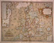
Elizabeth's England
 Picturing England | Elizabeth on Tour | Elizabethan Humanism | Elizabeth and the Poets

[Map of England]
Christopher Saxton
Atlas of England and Wales (London, 1579)
Newberry Library (Case +G 1045 .78)
View close-up

Saxton's Atlas is a collection of maps depicting every county in England. It was the largest and most detailed cartographic project carried out during Elizabeth's reign, and became a model for the modern national atlas.

Return to Picturing England

 Made possible in part by a major grant from the National Endowment for the Humanities. Any views, findings, conclusions, or recommendations expressed in this Web site do not necessarily reflect those of the National Endowment for the Humanities.
Copyright Notices
National Endowment for the HumanitiesAmerican Library Association
Home The Exhibit View Timeline Exhibit Floor Plan The Young Elizabeth Elizabeth The Queen Sedition and Succession Elizabeth's England Europe and America Legacy and Legend The Newberry Library